The combination of abundant streams and major mountain ranges of northern Idaho means there are an awful lot of places where the waters are literally falling down the mountains. While scores of waterfalls lie in remote parts awaiting discovery by adventurous hikers, there are many beautiful waterfalls with well developed access that are wonderful to behold.
These eight falls were featured in the Summer 2024 Sandpoint Magazine.
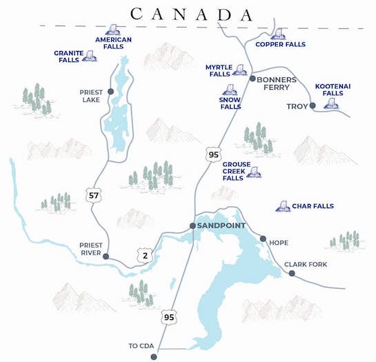
Char Falls
Located east of Sandpoint via a 16-mile drive on gravel roads, Char Falls entails a hike of less than a mile. When you've reached a flat bench with a set of small cascades... you're just at the top of the main attraction. There's a bit of a sketchy rocky path that leads down the steep embankment to get to the foot of the falls. Click for Google map.
Kootenai Falls
Kootenai Falls east of Troy, Montana, is one of the largest undammed waterfalls in the West and truly a spectacle to behold. It's a bit more than an hour's drive from Sandpoint to this major falls where the Kootenai River steps down in multiple cascades. There are paths that lead to the south side of the falls, as well as a path downstream that leads to a swinging bridge across the broad Kootenai River to its north bank and, for the adventurous, a long trail that leads high up above the falls. A tumble here down the steep mountain would put you in the raging waters, so exercise great caution. Click for Google map.
Grouse Creek Falls
Of this list, Grouse Creek Falls is the closest to Sandpoint, located off of Grouse Creek Road. It's only a half-mile hike to reach it; the trail forks towards its end, with the right fork landing you a bit downstream of the falls. The left trail will take you up over a ridge with a very steep down-climb that will put you right below the main falls, which cascades down about 15 or so feet. Click for Google map.
Snow Creek Falls
Beautiful and accessible Snow Creek Falls is located about nine miles southwest of Bonners Ferry on Snow Creek Road #402. There's both a lower and upper falls, with wooden stairs and an observation deck at the first. The lower falls drop about 20 feet, and the upper about 30. Click for Google map
Myrtle Creek Falls
Within the Kootenai National Wildlife Refuge, about seven miles west of Bonners Ferry, Myrtle Creek Falls is a short but steep hike above the refuge headquarters to a viewpoint. It drops a total of of about 100 feet. Click for Google map.
Copper Falls
Near the Canadian border you'll find popular Copper Falls, considered well worth the drive by visitors. With a 1.4 mile loop trail that includes benches along the way and an observation deck for viewing, the 225-foot drop of the falls is the tallest on this list. Springtime is prime time, with higher flows; the falls reduce over the course of summer as Copper Creek's flow slims down. Click for Google map.
Granite Falls
Granite Falls lies northwest of Sandpoint near Nordman. It's a one-mile loop trail with a spur trail that takes you to the lower falls. A wooden walkway is the viewpoint for the upper falls. Lasota Falls is hidden between the two. A bonus to Granite Falls is that it's located within the Roosevelt Grove of Ancient Cedars, trees that are estimated to be about 3,000 years old. At high water, there are almost 50 falls that are part of this system. Click for Google map.
American Falls
Take a hike through a glorious ancient forest to reach Upper Priest Falls, which is also known as American Falls. It's a good-sized hike, about 9.5 miles, but easy walking with little more than 700 feet of elevation gain. And trail #308 is also the beginning (or end, depending on direction of travel) of the Idaho State Centennial Trail. Click for Google map.