 By Billie Jean Plaster, Chris Bessler and Jane Fritz, with portions excerpted from the book "Wilderness of Water: Legendary Lake Pend Oreille."
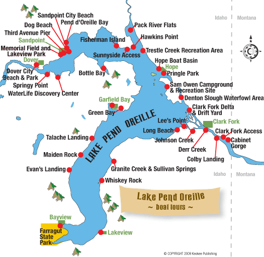
See Pend Oreille from a boat!
At 43 miles long, 6 miles wide and with 111 miles of shoreline, Lake Pend Oreille offers many great boat excursions.
If you don't own your own boat, rentals of sail, paddle and power vessels are offered at a number of marinas in towns around the lake. See the Boat Rentals & Service page for leads to marinas closest to the departure point you prefer, or check the Super Directory under Marinas & Boating Services.
Boat charters, which include the captain and crew to handle actually piloting the boat, are also available. Or if you're more interested in experiencing the lake in the intimacy of a paddle craft such as a kayak or canoe, several companies offer rentals or guided tours. Check the Boat Rentals & Service page for resources, or click to go to Tour Guides & Outfitters in the Super Directory.
Below are some good lake destinations for boaters, listed in order from the south end of the lake and moving north and then east.
Buttonhook Bay
The very southern tip of the lake adjacent to Bayview has a bay named after the hook used to lace up old fashioned boots, the buttonhook. Scenic Buttonhook Bay offers very well-protected waters with several public boat docks and slips. Boats can dock or anchor overnight in the shallow waters. On shore at Farragut State Park, a foot trail leads hikers up above the bay for excellent views across the lake. Going the opposite way takes you to Beaver Bay, a developed swimming area. North of Beaver Bay, there is another public launch area with picnic sites called Eagle Boat Launch.
Bernard Peak
Mountain goats thrive at Bernard Peak near Echo Bay after being planted there in the early 1960s from Snow Peak in the North Fork of the Clearwater. Boaters may drive to the shore where the point juts out into the lake to spot the white beasts in their precipitous home. You're quite likely to see at least some of the 30 or so that live on the cliffs. Spotting scopes are found across the lake at the Willow Day Use Area inside Farragut State Park.
Lakeview
Departing from the Eagle Boat Launch at Farragut State Park or from Bayview, it's an easy trip across the lake to Lakeview, where the county maintains a public dock flanked by private property. Lakeview is surrounded by abandoned limestone mines. Much of the town is situated on a bench well above the lake. Three miles above Lakeview is the Happy Hermit Resort that operates year-round, catering to snowmobile enthusiasts in the winter. Lakeview is also accessible by car on Forest Service Road 278. See Lake Drives.
Whiskey Rock Bay
At Whiskey Rock Bay, boaters can pull into a protected cove where they can enjoy swimming or hiking around the area, or even camping. During summer's high pool, the rock itself is pretty tough to spot: It's submerged during high water and marked with a navigation light.
Cunninghams Castle
About a mile south of Whiskey Rock, is the old site of Cunninghams Castle. Rumored to be the site of a former bordello and the headquarters for whiskey runs during Prohibition, the site is empty now. Old-timers can remember seeing the castle-like structure back in the 1950s. However after the Forest Service acquired the property, it was burned down. The site is also accessible by car on Forest Service Road 278. See Lake Drives.
Maiden Rock
Maiden Rock is an enormous block of granite jutting out into the lake about two-thirds of the way down the west shore of the lake's south arm. Boats may pull up on the beach, but there are no docks. There is a Forest Service recreation site with picnic tables and camping. Hikers can scramble to the top of Maiden Rock for a fantastic view across the lake. Maiden Creek Trail No. 321 accesses Maiden Rock by foot, horseback or motorbikes.
Garfield Bay
From Garfield Bay, boaters can cross the broad reach directly across the lake to the foot of the Monarchs on the opposing shore, to Windy or Indian points. Or head northeast to nearby Green Bay, where there's a campground and swimming beach. Look for a rope swing on the rocky point at the west end of Green Bay. From there you can go farther northeast to Mineral Point and Anderson Point, passing several bays and Picard Point on the way. Or conversely, head south, toward the more distant Talache Landing or Maiden Rock.
Contest Point
A good excursion from Sandpoint proper is south and east across the lake to Contest Point. From here you can cruise into long narrow Bottle Bay, with Bottle Bay Resort (208-263-5916) a possible destination. If you venture a few miles north and east back across the bay you can cruise by tiny Fisherman Island, a day-use only area managed by Idaho Fish and Game, off the Sunnyside Peninsula before returning to Sandpoint, completing what's known as the "Boaters Triangle."
Long Bridge to Dover
Though not technically the lake, the water west of the Long Bridge to Dover is often considered Lake Pend Oreille. Boaters can depart from Memorial Field, Dover Bay or Springy Point to explore downriver as far as Albeni Falls Dam. A good stop along the way would be Riley Creek Recreation Area at Laclede on the Pend Oreille River, where there's a swimming beach, playground, campground and walking trail.
Sunnyside Access and Hawkins Point
Sunnyside Access and Hawkins Point are suitable for launching small boats for fishing around Sunnyside Peninsula or in the Pack River Flats south of Idaho State Highway 200.
Pack River Wildlife Management Area
Launching at the Pack River Flats, boaters can explore the Pack River Wildlife Management Area, designated as a no-wake zone. Small car-top fishing boats may head downstream of Highway 200 to the railroad trestle, while only non-motorized craft are allowed upstream of the highway.
Hope area
In the Hope area east of Sandpoint, boaters can tour around several small islands including Warren, Cottage, Pearl and Memaloose. Memaloose was once an Indian burial ground and sacred site. The islands are private, so don't go ashore without permission.
Monarch Mountains
>A trip south across the lake from Hope will take boaters to the majestic, magnificent Monarch Mountains. Starting at the navigation lights at Lee's Point near the mouth of the Clark Fork River, the shore below the Monarchs stretches across an area known as "Long Beach." Some people camp along this stretch managed by the Forest Service. Although the campsites are primitive, there are a couple of vault toilets. A fire storm in 1991 burned much of the Monarchs. Farther east is Deadman Point, Indian Point and Windy Point.