| |
|
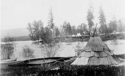
This 1860 photo shows a Kalispel canoe and tule-mat tepee in the foreground across from an American camp on the Pend Oreille. The indigenous Kalispel Indians prospered around the Lake Pend Oreille region, where they hunted, fished and traded along its shores for thousands of years. When David Thompson, a North West Company fur agent and surveyor, arrived in September 1809, he initially named the lake “Kullyspel Lake” after the Kalispel Indians who lived here.
The Bonner County Historical Society Collection
|
By Billie Jean Plaster, Chris Bessler and Jane Fritz, with portions excerpted from the book "Wilderness of Water: Legendary Lake Pend Oreille."
ON A MAP, LAKE PEND OREILLE looks like an ear, or perhaps a question mark missing the dot. Not that you can really tell much about its shape when you're down on the water. It's simply too big to discern much more than water, sky and mountains stretching on and on.
How big is big? Well, for instance, the 43-mile-long lake is nearly as long as Lake Ontario. At its greatest girth, the lake is just over six miles wide. And in one respect it outdoes all but four lakes in the nation: It's a lot deeper.
Big Depth
In fact, when we say our lake is deep, we mean it is deeper than the famous Loch Ness. The U.S. Navy didn't choose to test submarines at Lake Pend Oreille for nothing. It is even rumored that the Navy once lost a submarine in the deep, dark waters. At 1,158 feet deep, it's the fifth-deepest lake in the nation. The Navy still continues to perform tests in Lake Pend Oreille from its Acoustic Research Detachment at Bayview. And like Loch Ness, our lake is also reputedly the home of a large water monster, affectionately called Pend Oreille Paddler. Actually, the various sightings could be giant sturgeon, which historically reached lengths of 12 feet and longer, but doubts linger.
Big Shoreline
If you wanted to paddle around the lake's shore in a kayak, you would have to make approximately 118,539 strokes with an oar to follow the 111 miles of shoreline.
If you are somewhat less ambitious – or have less than the week or so that a circumnavigation might take – there are plenty of places where you can reach the lake by car, bike or foot, or can launch a boat. Check out the
Lake Towns page, or go to the
Lake Drives page.
Big Geology
Many visitors to Lake Pend Oreille are captivated by its rugged beauty that begs comparison to the fjords of Scandinavia. The exceptional beauty comes courtesy of the surrounding mountain ranges that, in areas, seem to plunge straight up out of the depths of the lake. The three major mountain ranges that surround the lake are the Selkirks to the north, Coeur d'Alenes to the south and Cabinets to the east.
Lake Pend Oreille lies within the Purcell Trench, a chasm in the Rocky Mountain chain that stretches a couple hundred miles from the Idaho Panhandle well into Canada. This steep-sided valley was created by forces deep in Earth’s crust hundreds of millions of years ago. Sediments in a vast seabed from the obscure past buckled and rose, forming the ancient mountain range of the Cabinets. Then igneous intrusions pushed their way to the surface and in a cataclysm of mountain building, the Selkirk Mountains were born around 135 million years ago.
The narrow but long valley embraced by these two mountain ranges became the perfect home for big rivers and deep lakes. At its south end, the stage was set for a water event of gargantuan proportions, now known as the Ice Age floods. Thousands of years ago the Idaho Panhandle was covered with ice. The Purcell Lobe of the continental ice sheet was as much as 2,000 feet thick at the mouth of the Clark Fork River. An immense lake that filled the valleys of western Montana was created. When that ice dam melted and collapsed, reportedly over and over again, 10 times more water than what flows in all the rivers of the world today rushed into the abyss that now cradles Idaho’s most precious gem. Lake Pend Oreille is a remnant of the former glacial lake that preceded it, but Pend Oreille is no less spectacular, no less beautiful than its ancestor, Glacial Lake Missoula.
Big History
There is a long history of human activity around Lake Pend Oreille. Not long after the continental ice sheet receded, native peoples hunted, fished and traded along its shores. For thousands of years indigenous tribes prospered here. Then, in September 1809, David Thompson, a North West Company fur agent and surveyor, arrived from Canada and set his eyes on this beautiful body of water, immediately recognizing its intrinsic value. Written in his later years, his memoir states, “The impression of my mind is, from the formation of the country and its climate, its extensive Meadows and fine forests, watered by countless brooks and Rills of pure water, that it will become the abode of civilized Man, whether Natives or other people.”
Thompson initially named the lake “Kullyspel Lake” after the Kalispel Indians who lived here. Perhaps one of his voyageurs gave the lake its French name – Pend d’Oreille. Translated, it means “ear pendant,” possibly referring to jewelry worn by a Kalispel they encountered, even though it wasn’t tribal custom to wear earrings. Or maybe the name described the lake’s shape as an ear. This is the name that endured, but sadly with the spelling altered: the d’ (apostrophe) was dropped in use over the years.
There are less than 400 Kalispel Indians now, most of whom live on the tribe's small reservation on the Pend Oreille River in Usk, Washington, and the tribe is not officially recognized in Idaho. But the lake is very much their home ground, and well into the 1930s Sandpoint was the site of annual gatherings of Kalispel, Kootenai and other tribes who held horse races, played traditional games and kept their culture alive.
The lake's colorful history includes the gold rush era beginning in 1866, when the lake was used as a thoroughfare for prospectors traveling from the Columbia River to the gold fields of Helena, Montana. Steamships like the
Mary Moody took miners from Buttonhook Bay north up the lake and then east up the Clark Fork River as far as the impassable Cabinet Gorge rapids until 1869 when the gold rush died down.
The lake's largest community, Sandpoint, was first settled in 1880 when Robert Weeks opened a general store, and the Northern Pacific (NP) surveyed the area. To learn more about the town's fascinating railroading history, click to
read this story in the Summer 1995 issue of
Sandpoint Magazine. The town grew slowly from then on as a mining and timber center. Read more about the area's logging history in
"Timber Town," published in the Summer 1994 issue of
Sandpoint Magazine. Hope was once a booming railroad community with the construction of the NP line in 1882. The Chinese who worked on the railroad lived in the community until the 1920s.
A big chapter in the lake's history was written during World War II, when Bayview was the site of the Farragut Naval Training Station through which some 300,000 enlisted men passed. Click to read a fantastic story on the
history of Farragut, "Sailors Ahoy!" published in the Summer 1996 issue of
Sandpoint Magazine. There is still a naval research station in Bayview. The community was also busy early this century when mines and lime quarries flourished.
In 1955, the Army Corps of Engineers built the Albeni Falls Dam on the Pend Oreille River, the outlet of the lake. Today, lake levels are controlled by operations of the dam. At full summertime pool, Lake Pend Oreille is at an elevation of 2,062 feet. Its maximum wintertime drawdown is 2,051 feet. A second dam exists on the east end of the lake, seven miles upstream on the Clark Fork River. The Cabinet Gorge Dam was completed in 1952 and is privately owned and operated by Avista Utilities of Spokane, Washington.
Roads were pushed through the dark forests onto all sides of the lake by the 1950s. However, it remained difficult, if not impossible, to get to every part of the lakeshore. To this day, much of the lakeshore only is approachable by watercraft. Much of Lake Pend Oreille’s shoreline is simply too steep and rugged for a road. Highway 200 parallels the northeast side of the lake connecting Sandpoint to Hope and Clark Fork. A few roads have been punched into premium locations like Talache Landing, Garfield Bay and along the lakeshore to Bottle Bay on the west side. At the south end are the communities of Bayview and Lakeview, while the most remote outposts are on the lake’s east shore at Granite, Cedar Creek, Whiskey Rock and Kilroy Bay.
Meantime, there's no shortage of historical vignettes from the lake's colorful history. Once such was a scandal surrounding the community of Midas, now Garfield Bay. Copper ore was found in this area and a town sprung up here after a mine opened in 1909. James McNicholas, a shyster who bilked Eastern investors into thinking the surrounding mountains were loaded with gold, named the town Midas. By the time folks discovered that he had simply laced the mines with some of the precious minerals, McNicholas had run off to Oregon. Other mines followed, but the town never did have a productive mine.
These days it's just the natural beauty of the lake itself that is the gold mine, attracting visitors from around the world to appreciate its many attractions.