 To Sample the Beauty, Take a Hike
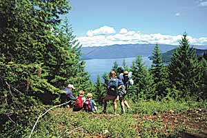
The beautiful country around Sandpoint provides outstanding walking for hikers of all ages, abilities
By Valle Novak
The diverse woodlands of northern Idaho offer pristine beauty to lovers of the outdoors. Though visitors marvel at the rugged peaks to be seen in every direction and admire the exquisite lakes and waterways, the best way to really appreciate their wonders is to walk through them.
There are a multitude of hiking trails in the surrounding forests. Some lead the hiker through high hillside meadows that afford a view of other far-distant mountains; some wind through trees and rock-scapes to unexpected waterfalls or mountain lakes nestled like jewels in their aerie-like settings; others take the explorer through deep, cathedral-like woods, along rushing streams, or into virgin forest with great patriarchal cedars many hundreds of years old towering into the sky.
Along the way, a variety of wildlife may be seen, from big, lazy marmots sunning on rocks to mountain goats, bear, deer, moose, coyote and more, depending on where the traveler roams. Too, birds abound: Great blue herons, kingfishers, eagles and osprey, and a multitude of song-birds that regale picnickers and campers with ethereal melodies mingling with the scents of pine, spruce and wildflowers. In June or early July, the intoxicating fragrance of the syringa (mock orange), Idaho's state flower, may treat your senses.
Depending on the season, the hike can be enhanced by such delights as mushrooms, wild raspberries, dewberries, currants, and the succulent, sweet-tart huckleberry.
Trails exist and are maintained for all levels of expertise and endurance, but for family groups including children and/or elderly or wheelchair-bound, there are many choices as well. One such is the Mineral Point Interpretive Trail No. 82, high up on the shores of Lake Pend Oreille with frequent outstanding views across the lake toward the Green Monarch mountains.
Mineral Point has a short interpretive walking trail, a picnic area overlooking Lake Pend Oreille, and a toilet facility. All facilities and a portion of the interpretive trail are wheelchair accessible. The hike should take from a half- to one hour, depending on the amount of time you take at each stop. There is a bit of a climb on the return trip, but it is not too difficult for hikers of all ages.
For a longer outing, the hike can be extended for about two miles to walk to lovely Green Bay, where the trail drops down to the water and there's swimming.
To get to the Mineral Point trail, drive about five miles south of Sandpoint off Highway 95, turn east on Sagle Road. Follow the road about nine miles and bear right at the fork pointing to Garfield Bay. Go past the Garfield Bay campground and picnic area and at the next fork (there will be a small marina on the shore), go uphill to the left. In the next half mile, look for the sign for Trail No. 82 and turn right past a large barn. You'll now be on Road No. 532, a dirt road. After about four miles you'll reach the Mineral Point area and should be seeing signs for Trail 82. At the first fork (a junction with 2672) stay to the left; at the second fork (junction of 532 and 532A) stay to the right. Another half-mile or so brings you to the trailhead. The long drive is well-marked and is the perfect opportunity to become acquainted with the beauty of the area.
Another good family trail, Gold Hill Trail No. 3, is accessed from the same original coordinates, but instead of turning onto Garfield Bay Road, continue on six miles to Contest Mountain Road 2642 (located on the left at the hairpin turn); take Road 2642 six miles to the upper trailhead. Length of the route is 3.7 miles one way. This trail offers panoramic views of Lake Pend Oreille, Sandpoint, the Selkirk Mountains and the Pend Oreille River. Visitors will also enjoy various views and forest settings the entire length of the trail. Carry water and some mosquito repellent. The stunning views cry out for a camera.
A good idea for Gold Hill Trail No. 3 would be to use two vehicles, leaving one at the end of the lower trailhead. This is reached by taking Bottle Bay Road (about two miles south of Sandpoint) off Highway 95. Drive 4.8 miles to the lower trailhead located on the right side of the road. One can, of course, reverse the process and hike the trail from the Bottle Bay side.
A final trail suggestion, Moose Lake Trail 237, is reached by taking Highway 200 about 5 miles east of Sandpoint to Trestle Creek Road 275. Turn left on Road 275 and go 16 miles, turning left on Road 419. Go 1.5 miles to Road 1022 and turn right to the end of the road. Moose Lake Trail 237 begins here at 4,920-foot elevation and has a length of 1.6 miles one way to an elevation of 6,160 feet. Trail condition is good, and hiker class is easy. The trailhead has a parking area and vault toilet.
The trail also provides access to Blacktail Lake Trail 24, and Lake Estelle Trail 36. Limited camping is available at Moose Lake. Take repellent for the insects and a camera for the moose.
The U.S. Forest Service Ranger Station at Sandpoint has booklets and maps of hiking trails, campground and picnic areas and a mountain bike guide for the northern panhandle. There is also a Ranger Station at Priest Lake, for more great hiking possibilities.