 by Jamie Emmick
by Jamie Emmick
As you tour Lake Pend Oreille this summer whether hiking, sailing, canoeing, fishing, boating or driving its expansive girth you'll be seeing waters of the region on their own tour, journeying west to the Pacific Ocean.
In its essence, Lake Pend Oreille is a huge natural reservoir for a watershed covering 22,000 square miles of western Montana and nearly 1,000 square miles of northern Idaho. The lake's great size and depth most often impresses visitors. As a natural system, it dominates the area, affecting the fish, wildlife, people, plants and even the climate here.
You could say Lake Pend Oreille starts in the Rocky Mountains of Montana more than 200 miles to the south and east. The winter snow on the Bitterroot, Flathead, and Mission ranges melts as summer approaches, collecting in a web of rivers that all eventually drain into the Clark Fork River, the lake's major tributary.
While most waters come to Lake Pend Oreille via the vast Clark Fork drainage, many small rivers and creeks feed the lake, the largest of which is Pack River, which meanders into the lake from the north.
Carved by Glaciers
The basin in which the lake sits was carved out during the Pleistocene ice age, starting perhaps as long as 100,000 years ago and ending 11,000 years ago. Mighty glaciers scoured many geographical features, and glacial meltwaters also flowed through the region.
These glacial meltwaters encountered a dam a natural barrier much larger than any man-made dam today. An ice dam was formed when a lobe of the continental glacier covering British Columbia pushed south into Idaho through the Purcell Trench between the Selkirk and Cabinet Mountains. As the ice advanced to the area of the present-day lake, it gouged out the deep basin in which lake waters later collected.
As the great ice sheet moved this far south, an ice lobe blocked the waters draining from the east through the Clark Fork valley. Waters accumulated behind the ice dam to a depth of 2,000 feet, creating the largest known glacial lake, Lake Missoula, which covered much of present-day western Montana.
The temporary ice dam eventually broke, unleashing waters that rushed westward across the Rathdrum Prairie and the Spokane Valley toward the Pacific Ocean. These Spokane Floods are believed to be possibly the greatest floods ever to have occurred on earth. The flood waters left in indelible imprint on the land, creating eastern Washington's channel scablands where even today it is possible to see evidence of the roaring waters. The glacier that caused these catastrophic events retreated 10,000 years ago with the end of the ice age, leaving behind today's dramatic landscape.
A Mighty Big Lake
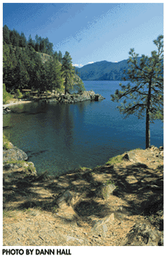
Today, Lake Pend Oreille's wayward waters wash up against 111 miles of shoreline made of steep cliffs, sand and pebble beaches and grassy banks. They encircle five islands. Altogether the lake stretches 43 miles long and over six miles across at the widest point. It reaches extraordinary depths of over 1,100 feet.
People can enjoy the natural wonder of our huge lake in many ways. Hike or bike the trails that follow the lake or head up a hillside in search of a view. In a motor or sailboat you can visit isolated bays and beaches, or circle the islands.
The surface of the lake reflects the surrounding Selkirk, Cabinet and Coeur d'Alene mountain ranges, whose peaks rise to elevations of over 6,000 feet. From Sandpoint's City Beach you can tour the lake on a cruise boat and enjoy the view of those ranges. Boat rentals or charters are available from a number of other communities around the lake, including Hope, Garfield Bay and Bayview.
Home to many animals
Charter a fishing boat to see firsthand what's living in the watery depths. Drop a line for the mackinaw trout, kokanee salmon and the record-sized Gerrard rainbow trout that inhabit the lake's deeper waters. The lake's shallower waters are home to other species. In the bays, you may have a chance at largemouth bass and perch. Westslope cutthroats prefer the surface water and shoreline along with bull trout, whitefish and brown trout, where you can fish from shore.
Many kinds of wildlife live around the lake. A variety of birds and waterfowl thrive in the wetlands of the Clark Fork River and Pack River deltas as well as the grassy banks along the Pend Oreille River. You're likely to see swans, geese, ducks, loons, osprey, bald eagles and great blue herons, among others.
You can spot many kinds of mammals in the forested areas surrounding the lake. The Pack River flats are a good spot to see moose that wade into the murky waters to feed. Deer are abundant on the Hope Peninsula, but come to the waters from the woods all around. Cottonwoods, alders and birch trees hang over the banks of sloughs, providing beavers with their building materials and squirrels with their playgrounds. Mountain goats roam the steep cliffs of Bernard Peak at the lake's south end, near Farragut State Park.
Just outside Sandpoint you can take a walk or ride a bike across the Pedestrian Long Bridge, running alongside Highway 95 where it crosses the narrow end of the lake. Just west of the bridge, the lake ends and the Pend Oreille River begins, its channel narrowing to the west. The river's waters have been held at lake level since the Albeni Falls Dam was built 25 miles downstream in the 1950s. Driving along Highway 2 west of Sandpoint, you can follow the waters as they leave Lake Pend Oreille and are met by waters from Priest River just before reaching the dam.
Visitors to the Albeni Falls Dam can tour its powerhouse to learn how the waters create hydroelectric power as they spill over the 90-foot-high, 775-foot-wide barrier. The Pend Oreille flows a few more miles west into Washington, then north into Canada finally joining the Columbia River on its way to the ocean. n
Jamie Emmick, a Sandpoint High alumni, returned home recently with a degree in anthropology from the University of Idaho.