|

|
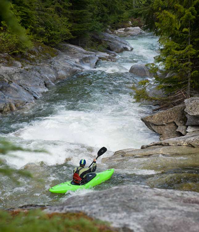
Nick Bandy dives into the "Guillotine" on the Upper Pack. Photo by Doug Marshall
On moving waters
Kayaking and lazy floats on the Priest, Moyie and Pack rivers
Whether for the thrill of whitewater or the quieter pleasures of wildlife and scenic beauty, area rivers offer a moving experience. Herein, two whitewater kayakers and a family floater share their insights on three of those rivers.
The Priest: A river for all seasons
If you set out to design a river for all sorts of paddlers, you would probably come up with something like the Eight Mile section of the Priest River. It combines flat water in a meandering course through broad pastures during the first few miles, then picks up steam as it winds into a minor canyon punctuated with Class II+ waves and holes that are candy for kayakers and rafters.
Yet the joys of boating the Priest aren't as much for the rapids as simply the pleasure of being on a river. "Rivers," as a friend once observed, "pick beautiful places to live."
That the Priest has relatively small whitewater doesn't mean paddlers can't get into trouble. On one kayaking trip years back, a beginner friend flipped and swam a couple times – par for the course for those learning to master a kayak – but on a third swim, now fatigued, he let go of his paddle and it got away. He had to pull off the river.
The Priest enters the Pend Oreille River at the town of Priest River, after running due south out of Priest Lake for 40 river miles, collecting all the waters of a huge basin gouged out of the Selkirk Mountains. The basin gets a lot of snow each year, which makes for some healthy spring runoffs – more than 6,000 cfs – producing whitewater in May and June.
As summer arrives and high water subsides, the river remains floatable but switches gear. By high summer of late July into August, the Eight Mile run is a popular inflatable and inner tube float. In fact, my fondest memories of this river aren't from some derring-do in the rapids but from lazy inner tube floats on blazing hot summer days - with some splashy riffles for excitement. (Some words to the wise here: After you start there is no good public access until you approach town. If you're on an inflatable, it is a long float that you should start well before noon, and can get chilly. There are riffles and moving water that demand caution, and it's not suitable for young children. Bring a life jacket and some food.)
But that's just an approximately eight-mile chunk of the lower river. In spring there's another short whitewater run, of three miles, from below the outlet of Priest Lake to the Dickensheet Campground. Though short, it is a more continuous Class II+ run that some kayakers prefer for the greater concentration of waves and holes. And one long spring day I paddled the whole river, from lake outlet 40-some river miles down to town. What I remember best, aside from some interminable flat-water meanders in the run's midsection, are the bank swallows – several colonies of hundreds of birds that had burrowed their nests into high silt banks.
As they swooped and swirled around us, it was like floating through a maelstrom of birds – ones with good taste. They, like the river, had picked a neat place to live.
– Chris Bessler
Put-in/takeout: The Eight Mile run has a convenient put-in at McAbee Falls (more a riffle than a falls) at the bridge where the Peninsula Road, also known as McAbee Falls Road, crosses the river. It's just a stone's throw from the Green Owl Tavern. Take-out is at the Mud Hole park just east of town, at the confluence of the Priest and Pend Oreille rivers, where there are nice park amenities, a sandy swimming beach and boat docks, but not much mud. A commercial outfitter offering trips, all gear provided, is All About Adventures in Sandpoint, (208-263-6959, AllAboutAdventures.com).
The Moyie: A classic whitewater run
Despite the fame, in certain quarters, of the four-wheel festival called the Moyie Springs Mud Bog, there's a lot more than mud in Moyie. If you're looking for excitement, maybe you should think more water and less mud. More specifically, you should be thinking Moyie River, a classic whitewater run about 40 miles north and east of Sandpoint.
Picture this: You're at ease in your boat, having just paddled through a series of standing waves, admiring the steep walls of the Moyie River canyon around you. As the sun warms and relaxes you, you look down only to find a 50-foot-tall wall of concrete dead ahead where, from the distance upstream, the river seems to almost disappear. Approaching the ominous structure, you begin to feel uneasy. With no place to go but downstream, towards the wall, you proceed with caution.
At the last second you see the dam has been breached at its far left and your tension melts with the sight of a waterfall cascading into the river past the breach. Stroking through a pool where the Skin Creek waterfall is cascading into the river, you blast down a drop and into the eddy below the concrete skeleton of the Old Eileen Dam with a smile of relief.
"The Dam" is but one of the Moyie's two signature rapids. The second comes a couple miles downstream, another great class III rapid called Hole in the Wall. It's a roller-coaster drop through big waves before you punch into the Moyie Reservoir, where the laughter and talk about who was the most scared carries you along as you paddle a final quarter mile of reservoir to the takeout above the Moyie Dam.
This is just the tail end of what the Moyie River has to offer whitewater rafters and kayakers alike, and even expert canoeists. The eight-mile whitewater section is strung together by tall wave trains, pushy Class II and III rapids and sunny lunch spots. The river is such a classic that a pair of commercial outfitters run trips during the May-June season (see access info below for contacts). The river is at its best at flows of 500 to 2,500 cfs – and above about 2,000 cfs, the Dam becomes considerably more difficult.
Above the canyon is another 10-mile class II swift water section, giving beginner whitewater adventurers a chance to get out and enjoy the scenic Moyie River.
The Moyie is a spectacular, close-to-home run that offers a beautiful, exciting way of seeing northern Idaho.
– Nick Bandy
Put-in/takeout: From Bonners Ferry, head north on U.S. Highway 95 to Three Mile Junction, then east on U.S. Highway 2 for two miles to a left turn onto Meadow Creek Road. After about nine miles you'll cross the Moyie at the Meadow Creek bridge; go about a half mile upstream to find an undeveloped parking area streamside on the left. The takeout is on the reservoir above the Moyie Dam, reached by turning at the Moyie Springs Store on U.S. Highway 2 and winding down the access road to the dam. Commercial outfitters offering trips are Coeur d'Alene-based ROW (800-451-6034, ROWadventures.com) and Bonners Ferry's 3 Heart Outfitters (208-267-5858 3HeartOutfitters.net).
The Upper Pack: A 'project' for experts
If I had to describe the Upper Pack River in just one word, I couldn't do it. I could possibly pull it off with three words – pristine, wild and pure. The Upper Pack tumbles down out of the Selkirk Mountains north of Sandpoint. As a whitewater kayaker and Sandpoint native, I can honestly say that the Pack is my favorite. It is a steep, low-volume creek that offers challenging Class IV, V and V+ rapids to any worthy opponent.
The river does have a softer side, counter-balancing the roar of the whitewater. Embedded in smooth granite, the Pack River's cold, clear water is home to trout. Combining the river, thick forest and abundant wildlife, the Pack River drainage provides endless opportunities for any outdoor enthusiast.
The Upper Pack River can be broken into three sections, providing whitewater kayakers with stepping stones into "steep creek" boating. All the sections are rated at least Class IV, and the farther you drive up the road, they become solid Class V runs.
The first and lowest section is called "The Gorgette," three miles consisting primarily of small Class IV boulder gardens, with one larger more technical Class IV rapid in the middle of the run.
From here you can step up to "The Slides" section. This, in my book, is where the Pack's beauty jumps up a peg or two. The run takes on a smooth, water-polished granite character for three miles, creating fun slides and ledges. The rapids here are mostly Class IV with a couple Class Vs thrown in.
The next stop is a two-plus mile section, "The Grottos," in the uppermost Pack – the keeper of fun, adventure and adrenaline that demands good teamwork and a solid set of skills. This is a stout Class V run with sticky spots coming in at Class V+. It packs a punch with waterfalls, gorges and technical slides.
So there you have it: Less than an hour from Sandpoint is a pristine playground that will test you, teach you and awe you every time you pay it a visit.
– Nick Bandy
Put-in/takeout: From U.S. Highway 95, turn west onto Pack River Road for 12 miles to the upper bridge – the take-out for the Slides and the put-in for the Gorgette. The take-out for the Gorgette is back down the road a couple miles. The put-in for the Slides is up the road past the bridge a couple miles. Continuing up the road turn left on Road No. 2653 and follow it to the trailhead for Chimney Rock, which doubles as the put-in for the Grottos.
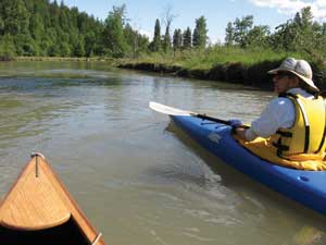
The Lower Pack: Family-friendly floats
|
Kayaking the lower Pack River,
photo by Brent Clark |
After Pack River crosses under U.S. Highway 95, it turns into a meandering waterway through the pastoral Selle Valley until it empties into Lake Pend Oreille at Idaho State Highway 200. Though the valley is well-populated, the waters pass through surprisingly vacant land. The Lower Pack still offers wildlife spotting: ospreys, herons, eagles and moose. It's a key migratory corridor for threatened bull trout.
Although it's flat water, during spring runoff April to June, the Pack can have strong, hazardous currents. For the inexperienced or those looking for family-friendly, lazy water floats, July and August are best.
Consider these three stretches. Beginning at Highway 95, put in under the railroad trestle and expect to spend three hours to reach the first bridge on Colburn-Culver Road. The next section goes from the second bridge on Colburn-Culver, near Northside School, to Rapid Lightning Road at the Pack River Store and takes 1.5 hours. The final stretch – and probably the best – from Rapid Lightning to Highway 200 takes a good four hours; paddlers pass an old homestead in the Ginter Wildlife Management Area and The Idaho Club. Parking is limited at all put-ins/take-outs. Watch out for highway traffic on 200.
Lined predominantly with black cottonwood, willow and cedar, the lower Pack is dotted with wide sandbars and occasional rocks or well-placed rope swings for jumping off. The combination of scenery and serene water makes for a memorable day of family fun.
– Billie Jean Plaster
|
|
|